What will happen to the current traffic?
The shared street proposal removes rat-running from the neighbourhood but retains local access. Up to 88% of vehicles on Wellington Street have no origin or destination in the area: they are predominantly CBD-bound commuters using it as a shortcut. When a route like this is filtered, those trips largely evaporate or reroute from their origin rather than shifting to adjacent side streets.
There are two proposed options for Wellington Street in Clifton Hill. This site focuses on the shared street option, which we think serves our community better. See what both options involve.
Register your support now. Local or not, your support counts.
Just add your suburb so we can show councillors both local and broader backing.
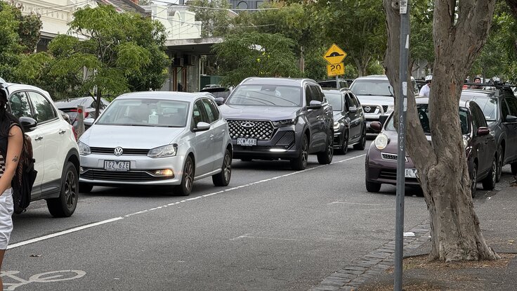
Who is actually using Wellington Street?
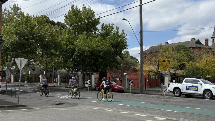
Council’s data, tabled at the Ordinary Council Meeting of 9 September 2025, found that up to 88% of vehicles on Wellington Street have no origin or destination in the area: commuters from distant suburbs, predominantly CBD-bound, passing through on the way to somewhere else. Up to 2,000 cyclists a day use it as well, a figure that increased significantly with the rollout of the improved infrastructure further south on Wellington Street and is likely to increase again when these improvements roll out, as well as the North East Link connection via Roseneath Street and South Terrace.
Where does displaced traffic actually go?
The council is not proposing to redirect traffic to side streets. The objective is to remove rat-running from the area entirely. Two things typically happen when a street is filtered:
Traffic evaporation. Studies consistently find a net area-wide traffic reduction of around 14 to 16% on filtered streets, with little or no corresponding increase on adjacent roads. The removed traffic does not simply move elsewhere: drivers switch modes, consolidate trips, or decide the journey is not worth making1.
Rerouting from the origin, not through the neighbourhood. Wellington Street is used as a commuter shortcut from the northeast suburbs to the CBD. When a route like this is filtered, navigation apps adjust from the driver’s starting point, before the vehicle reaches the area. A driver in Bundoora heading to the CBD will be routed around Clifton Hill before they leave home. The vehicles that would otherwise pass through on Noone or Hodgkinson Street are not diverted there by this proposal; they are rerouted at the origin.
In comparable schemes, some internal streets do absorb a portion of displaced traffic. In Walthamstow Village, four internal roads saw increases after filtering. The council monitored traffic, identified the affected streets, and applied targeted treatments, including a morning peak right turn restriction that reduced peak-hour traffic on Church Lane by 25%2. The net outcome across all streets in the area, including those that absorbed some traffic, was a 16% overall reduction in vehicle movements.
Comparable schemes consistently show that filtering a route reduces total traffic rather than shifting it to nearby streets3. Noone, Hodgkinson, and Gold Streets are unlikely to absorb what Wellington Street loses.
What has happened on similar streets in Yarra?
Yarra has already installed traffic barriers on Napier Street and Canning Street. Neither produced significant side-street traffic. There are at least 40 barrier locations across Yarra, including Page Street right next to Clifton Hill Primary School. The pattern is consistent, traffic displacement to side streets doesn’t materialise.
Air quality data from comparable schemes points in the same direction. NO₂ fell 5.7% within filtered areas and 9% on boundary streets, compared to control sites4. Boundary streets were not made worse; they improved.
Council staff will be monitoring traffic response after rollout and will apply additional treatments to mitigate them if post-construction monitoring shows impacts. It’s not a one and done process.
The “wider traffic masterplan” claim
It has been claimed that the proposals “do not consider the wider traffic masterplan.” Wellington Street is a C1 Primary Route in Victoria’s Strategic Cycling Corridors network, the highest classification. These proposals have been developed and assessed against that designation by council’s officers. The suggestion that no broader planning framework exists has it backwards: this project is part of that framework.
The type of filter matters
The shared street option uses partial traffic barriers, not full closures, unlike the existing full barrier on Page Street. Some rat-running can still find a route. The partial barrier is a compromise: it is less effective than a full closure at removing rat-running, but it also means Wellington Street remains navigable for anyone with a local destination (see the traffic circulation plan for how local access continues to work).
Option 2 proposes no traffic barriers at all, so will retain all the rat running at 40 km/h.
What about traffic from the Gasworks development?
The nearby Fitzroy Gasworks development will add many new homes to the immediate neighbourhood. Residents have raised concerns about what that means for local traffic.
Once the development is built and occupied, the baseline changes: new residents establish travel patterns, local traffic levels shift, and negotiating changes becomes harder. Getting the traffic management in place now, before those patterns are set, is easier than retrofitting it later.
-
Cairns, S., Atkins, S. & Goodwin, P. (2002). “Disappearing traffic? The story so far.” Proceedings of the ICE - Municipal Engineer, 151(1), 13–22. The 14-16% median area-wide reduction finding is consistent with the later Barcelona study: Nello-Deakin, S. (2022). “Exploring traffic evaporation: Findings from tactical urbanism interventions in Barcelona.” Case Studies on Transport Policy, 10(4), which found a -14.8% average (-15.4% median) net reduction on intervention streets relative to controls, with adjacent streets rising only 0.7%. See also: Better Streets Australia. ↩
-
London Borough of Waltham Forest, Walthamstow Village Scheme Review Report (2017). Of 12 monitored internal roads, the large majority saw substantial reductions (average -44%). Four roads saw increases: Church Lane, Vestry Road, East Avenue, and Third Avenue. The council responded with targeted treatments including a morning peak right turn restriction at the Church Lane/Shernhall Street junction, which reduced morning peak traffic on Church Lane by 25.2% (519 to 388 vehicles, 7am–10am). The net outcome across all streets including boundary roads was a 16% reduction in total vehicle movements. Scheme page: Walthamstow Village Transport Scheme. ↩
-
Thomas, A. & Aldred, R. (2023). “Changes in motor traffic in London’s Low Traffic Neighbourhoods and boundary roads.” Case Studies on Transport Policy. Covered 46 LTN schemes across 11 London boroughs; found a median -32.7% reduction in motor traffic on internal roads, with little indication of systematic displacement to boundary roads. ↩
-
Imperial College London, Low traffic neighbourhoods reduce pollution on surrounding streets (press release, 2022); Yang, X., McCoy, E., Hough, K. & de Nazelle, A. (2022). Transportation Research Part D, 113, 103536 (three Islington LTNs). A larger follow-up study covering all London LTNs implemented in 2020 found consistent results: Yang, X., McCoy, E. & Sheridan Mayfield, T. (2024). Transportation Research Part D, 131, 104225. ↩