Is the school safe under this proposal?
Yes. Both options install a raised zebra crossing at the school gate, physically slowing all road users and giving pedestrian priority 24/7. The shared street option additionally drops the speed limit from 40 to 30 km/h on the street segment past Clifton Hill Primary, substantially reducing the pedestrian fatality risk in a collision, and that limit applies to cyclists as well as motor vehicles. Under the shared street option, Wellington Street in front of the school becomes a local-access street with greatly reduced traffic volumes.
Register your support now. Local or not, your support counts.
Just add your suburb so we can show councillors both local and broader backing.
What the design includes at the school
There are two proposed options for Wellington Street in Clifton Hill. This site focuses on the shared street option, which we think serves our community better. See what both options involve.
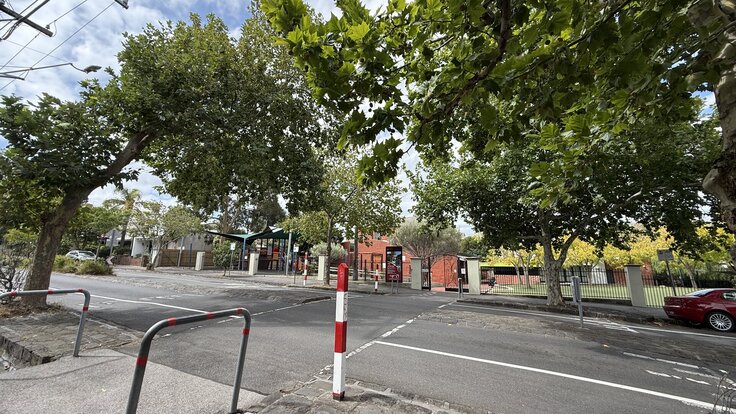
Both options include a raised zebra crossing outside Clifton Hill Primary. The current crossing is almost flat, enforcing no physical speed restriction, and has no zebra crossing, so only provides pedestrian priority when monitored during peak school crossing times. Both options also include speed humps further up and down Wellington Street.
The shared street option also reduces the speed limit on the southern sub-section (Alexandra Parade to Hodgkinson Street, which includes the school gate) from 40 to 30 km/h. Option 2 makes no speed limit change1.
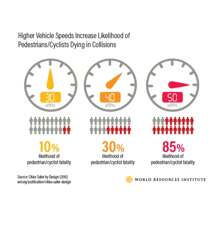
The risk of a pedestrian fatality in a collision falls substantially at 30 km/h compared to 40 km/h23. State policy now explicitly anticipates 30 km/h zones on streets directly abutting schools3. Clifton Hill Primary has a gate on Wellington Street. If the shared street option does not proceed, the speed limit on Wellington Street remains at 40 km/h and the rat-running traffic remains.
With rat-running removed and the speed limit dropped, the street in front of the school carries a fraction of its current traffic, moving at a speed where serious injury in a collision is far less likely.
Drop-off safety and access
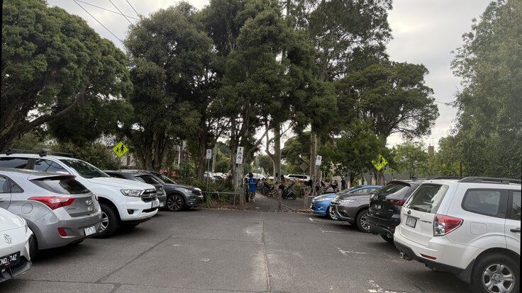
Some argue that fewer parking spaces will force parents to park further away, creating more dangerous crossings near the school entrance. Under the shared street option, 9 of the 13 bays removed on Wellington Street are in the northern sub-section between Hodgkinson Street and Queens Parade, remote from the school. The 3 bays removed near the school (1 beside Page Street and 2 at Council Street) create new pedestrian crossings. cern about dangerous crossings near the school gate and the parking losses near the school are the same infrastructure: those bays are removed to make room for pedestrians to cross, not for cycling. The remaining bays near the school will also be easier to reach: at busy times, through-traffic backs up along Wellington Street and a free bay is not much use if you cannot drive down the street to get to it. Once rat-running is removed, that congestion goes with it.
The proposal addresses drop-off safety rather than undermining it. Wellington Street currently carries a huge number vehicles per day past the school gate on that side. The traffic barrier south of the school removes the large majority of that volume. Drop-off problems at school gates are typically caused by too many vehicles competing for the same kerb: reversing, blocked sightlines, rushed manoeuvres. Collisions involving children concentrate near school gates during school travel times4, and traffic calming and through-traffic removal consistently reduce child pedestrian injuries in the areas where they are applied5. The Heart Zone programme in Denmark restricts vehicle access to school zones during morning arrival; schools in the programme report calmer conditions and a shift toward walking and cycling6. The petition’s drop-off safety concern describes the current situation, not what is proposed.
The barrier also changes how families approach by car from the south: the route shifts to Noone Street and Gold Street rather than Wellington. This adds some traffic to those streets at school times, but it is school-run traffic only, not rat-running. Council, Noone, and Gold Streets already have speed humps and pinch points, and afternoon pick-up falls in an otherwise quiet period on those streets.
All residences in the school zone are within 1.1 km of the gate (around 15 minutes walking or five minutes by bike)7. As Wellington Street becomes quieter, some families who currently drive because the route feels unsafe may shift to walking or cycling, particularly for older primary school students. Some parents who do drive may also choose to drop children a short distance from the gate rather than competing for kerb space directly outside: on a quieter, slower street, that short walk is no longer the concern it currently is.
Page Street already has a traffic barrier
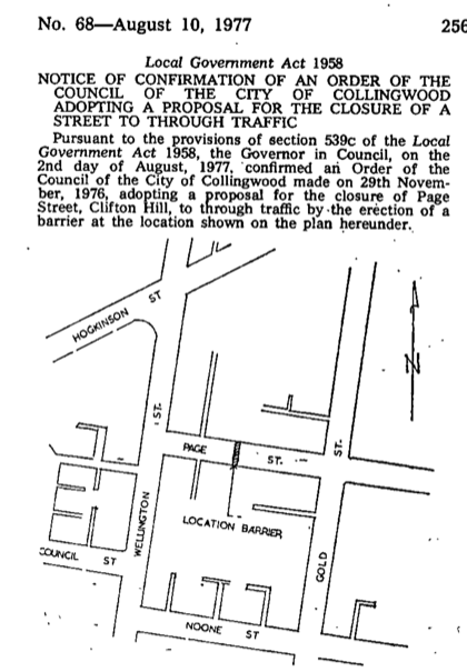
Clifton Hill Primary has buildings on both sides of Page Street, which runs along the northern boundary of the school’s primary site. Page Street has had a full traffic barrier in place since 1977, and students cross it daily.
It was put there after 47 residents of Page Street petitioned the then-Council of the City of Collingwood about dangerous traffic at the Page Street/Gold Street intersection. One of those residents was Marion Miller, a Page Street local who went on to become a Collingwood councillor in 1976 and Deputy Mayor in 1980. A temporary closure followed in 1973; the permanent closure was gazetted in August 19778. In a parallel to the North East Link today, many of the barriers that we take for granted today were motivated by concerns around the Eastern Freeway in the 1970s.
Traffic volumes in the early 1970s were a fraction of today’s. Residents judged conditions dangerous enough then to warrant a barrier and the case is even stronger now with higher traffic volumes and the North East Link coming.
Napier Street, Fitzroy
Napier Street in Fitzroy is a designated cycling corridor on the same Preston-to-CBD strategic route as Wellington Street. It has had a full modal filter directly outside Fitzroy Primary School’s Napier Street building since 2019, and the school has operated alongside it for six years.
The arrangement at Fitzroy Primary is the closest existing parallel to what is proposed at Clifton Hill Primary: a strategic cycling route with a modal filter and raised crossing at a school gate. The design features that make the Wellington Street proposal safe at the school gate are the raised zebra crossing, the speed limit reduction, and the removal of through-traffic. Fitzroy Primary has many of the same elements, including preventing through traffic, and it works well there.
Cyclist speed and volume
Wellington Street runs downhill heading south and southbound cyclists do travel faster on this section. The design addresses this with speed humps throughout and a raised crossing at the school. The shared street option also reduces the speed limit on the southern sub-section to 30 km/h, which applies to all road users, including cyclists.
If the concern is that cyclists travel faster than vehicles in this section, the shared street option addresses this in two ways. First, vehicles and cyclists share the lane rather than running side by side, so all road users travel at the same 30 km/h limit. A cyclist in a lane of traffic moving at 30 km/h is not going to ride faster than that traffic. Second, with more cyclists on the route, slower riders naturally moderate the pace of faster ones9.
The shared street also moves cyclists away from the kerb. A dedicated lane places cyclists immediately beside the footpath; in a shared lane, cyclists ride with the traffic flow in the middle of the road, putting more space between them and pedestrians waiting at the edge or stepping out from between parked cars.
At equal speeds, a car carries approximately 17 times more kinetic energy than a cyclist, by mass alone. In 13 years of crash data for the Clifton Hill section of Wellington Street, no pedestrian was recorded as injured in a bicycle crash10. Clifton Hill Primary already carries a huge number of vehicles past the school gate on Wellington Street, most of which are through traffic.
-
YourSay Yarra, Wellington Street North (Clifton Hill). ↩
-
World Resources Institute, Cities Safer by Design (2015). Gives the probability of pedestrian fatality in a collision at approximately 30% at 40 km/h and 10% at 30 km/h. Speed-fatality estimates vary by methodology; see also 3 for the Victorian government’s own figures. ↩
-
Department of Transport and Planning, Victoria, Speed Zoning Policy, Edition 3, August 2025. The policy states that pedestrians are “much more likely to suffer death or serious injuries at impact speeds above 30 km/h” (s 2.1.3, p. 6). Edition 3 (approved August 2025) also established 30 km/h as the standard speed zone limit for local streets abutting a school gate (Table 15, p. 22), and explicitly anticipates combining school speed zones with modal filters and raised crossings (s 3.7.2, p. 23). See also Streets Alive Yarra for an accessible summary of the policy changes. ↩ ↩2 ↩3
-
Warsh et al. (2009), Injury Prevention. Analysis of 2,717 police-reported pedestrian collisions in Toronto (2000–2005): over one-third occurred within 300m of a school, with the highest density within 150m, disproportionately involving children aged 5–9 during school travel times. PubMed 19651993. ↩
-
Two converging lines of evidence. On speed calming: Tester et al. (2004), matched case-control study, Oakland; speed humps associated with a 53–60% reduction in odds of child pedestrian injury or death (adjusted OR 0.47). PMC1448312. On modal filters: Laverty, Aldred & Goodman (2021), police injury data from Waltham Forest (2012–2019); injuries inside LTN areas fell three-fold after modal filter introduction, with no increase on boundary roads. Findings. ↩
-
Cycling Embassy of Denmark, Heart Zone programme. Operates across Copenhagen, Vejle, Aalborg, and Odense. Evaluations report reduced vehicle volumes during morning arrival and surveys showing improved perceived safety; participating schools report calmer conditions and a shift from driving to walking and cycling. No collision or injury outcome data have been published. ↩
-
School zone boundary from Find My Schools (Clifton Hill Primary School, school ID 1136001). 1.1 km is the walking distance from the furthest point in the zone (south-east corner, upper Abbotsford) to the Wellington Street gate, measured via Google Maps. ↩
-
Collingwood Historical Society, Marion Miller entry; Victorian Government Gazette No. 68, 10 August 1977. ↩
-
Eco-Counter, “Cyclists’ speed: when data helps with urban planning”. Analysis of data from over 500 bicycle counters across nine countries. The same analysis finds that only around 5% of cyclists exceed 25 km/h in normal conditions. ↩
-
Victorian Road Crash Data (Department of Transport and Planning, 2012–May 2025). Clifton Hill segment (Stage 4, Alexandra Parade to Queens Parade): 3 pedestrian victims recorded, all in motor vehicle crashes, none in bicycle crashes. Full Wellington Street corridor: 12 pedestrian victims, all motor vehicle crashes, none bicycle crashes. Statewide, bicycle-involved crashes account for 1.75% of police-reported pedestrian crashes and 1.62% of pedestrian fatalities (8 of 495 over the same period). Consistent with O’Hern, S. & Oxley, J. (2019), “Pedestrian injuries due to collisions with cyclists Melbourne, Australia”, Accident Analysis & Prevention 122, 295–300 (PubMed 30399525), which found 1.2% in Melbourne police data over 2006–2016. Corroborated by UK Department for Transport, Reported road casualties in Great Britain: pedestrian factsheet, 2024 (published September 2025, covering 2020–2024): cyclist-involved collisions account for approximately 2.4% of all reported pedestrian casualties and 0.47% of pedestrian fatalities (9 of 1,906 over the five-year period). ↩